Author Archives: Franklin Thompson

Historic Old Mill District

This photo of the Historic Old Mill District Walking Tour Map was taken in February of 2004. It was located near the Indian Punch Bowl on Riverside Drive in Fredericksburg. Historic Old Mill District, Fredericksburg, Virginia

Fredericksburg’s Historic Old Mill District dates its origins to the earliest settlers along the Rappahannock River. This walking tour takes you through what can be considered the city’s first industrial park as it winds along the Rappahannock and a parallel canal. These waterways and early 20th century industrial area to flourish.

[1] Indian Punch Bowl
Although the origins of this stone basin are not certain, it is said to have been used by Indians during hunting festivals as a punch bowl. Found by Major Francis Thornton (1862-1758) upon his land, it was inscribed by Thornton “1720”.

[2] Site First Mill (1720)
Owned by Francis Thornton, whose lands encompassed this area, the first mill ground produce of the Thornton plantation into meal and flour. Such mills were necessary in early colonial times, because plantations were self-sufficient.

[3] 1907 Dam and Gates
This dam and gate structure replaced an older dam dated back to the early 1800’s. Made of concrete, the newer dam was said to be “state of the art” and replaced the deteriorating older dam.

[4] Site Rappahannock Electric Light & Power Co.
Between 1822 and 1922, this section of canal supplied water to power the water wheel of the Rappahannock Electric Light & Power Co. Between 1900 and 1923, the Company was managed by Ellen Caskie London Ficklin, the first woman in the United States to head a public utilities company.

[5] Bridgewater Mills Foundations (1822)
This 150′ X 40′ brick mill, which was five stories high in part, could ship 150 barrels of flour and 400 bushels of corn per day. The first telephone in Virginia was hooked up between this mil and downtown. The mill won the silver medal at the 1878 Paris International Exposition.

Nearby Cooper Shop and Woodwork Shop
The Cooper Shop made the barrels that were used to ship the flour from the mill. A wood-working shop, also near the mi8ll utilized tools which were run by water power.

[6] Knox Bone Mill and Sumac Mill Foundations
In the 19th century, these mills ground bone into fertilizer for regional use in farming. Sumac, which grows locally, and used in tanning leather and dyeing textiles, was also extracted from leaves of sumac tree for sale throughout the United States. Sumac provided income to many Fredericksburg citizens, and was one of the principal industries of the city. The Knox Sumac Mill was one of the largest in Virginia.

The Historic Old Mill District Walking Tour Map on Riverside Drive was removed.

Related:
Indian Punch Bowl


Stonewall Jackson Shrine

12019 Stonewall Jackson Road, Woodford, Virginia

The Stonewall Jackson Shrine is approximately 14 miles from the Fredericksburg Visitor Center.

Stonewall Jackson Shrine MarkerWar Comes to Fairfield

War brought profound changes to the Chandler family, Fairfield, and the slaves who toiled on the plantation.  Three of Thomas Chandler’s sons enlisted in the Confederate army.  When the Union army occupied Fredericksburg in 1862 many of Chandler’s  slaves seized freedom, leaving the family without its customary workforce.

In December 1862 the Confederates established a major supply depot at Guinea Station, just a few hundred yards from Fairfield’s back door. Camps sprawled across the plantation.  Stonewall Jackson himself camped here for a week, declining Chandler’s offer to stay in the house.  Instead he pitched a tent nearby.

By 1863 Chandler had had enough: he sold Fairfield.  But before the Chandlers could move away, Fairfield’s most famous visitor would return yet again — this time not to camp but to die.  Jackson’s death here propelled the plantation to a fame it had never known.

Other Park Service markers at the Stonewall Jackson Shrine – click on any of the thumbnails to view the full readable image.

Stonewall Jackson Shrine Marker   Stonewall Jackson Shrine Marker   Stonewall Jackson Shrine Marker   Stonewall Jackson Shrine marker

Stonewall Jackson Shrine Gallery

[nggallery id=9]

Massaponax Church

Massaponax Baptist Church

Massaponax Baptist Church, built in 1859, served a congregation founded in 1788. On 21Massaponax Baptist Church Historic Highway Marker May 1864 Lt. Gen Ulysses S. Grant and his commanders conferred on pews in the churchyard as the Union army marched from the Spotsylvania Court House battlefield to North Anna River. Photographer Timothy O’Sullivan hauled his heavy stereo camera to the balcony of the church and recorded this conference in a unique series of candid images showing a war council in progress.

Massaponax Church

Massaponax Church Historic MarkerTwo weeks of fighting at Spotsylvania had resulted in a bloody draw.  On May 21, 1864, the Army of the Potomac left its trenches outside the village and began moving east and south, hoping to lure the Confederates into open where it could attach them to greater advantage.

At 10 a.m. Gens. U.S. Grant and George Meade broke camp near Spotsylvania.  They reached Massaponax  Church, on Telegraph Road, about noon.  After a brief conference, the generals and the army moved on to Guinea Station.

Photographer Timothy O’Sullivan caught up with the Federal high command during their brief stopover at the church.  He recorded a remarkable series of photographs of the generals and their staffs in conference.

Massaponax Church Civil War PhotoUnion soldiers a Massaponax Church, May, 1864.  This view looks west from Telegraph Road.  Many of the soldiers who appear in this photograph belong to the 114th Pennsylvania Volunteers, a regiment that was then serving as head-quarters guard for the Army of the Potomac. 

Gens. U.S. Grant and George Meade at Massaponax Church May 21, 1864O’Sullivan made this photograph through a window in the building’s gallery.  In it, Grant is seated on a church pew at the foot of the trees, flanked on his left by Secretary of War Charles Dana and Chief of Staff John A. Rawlins.  Meade occupies the pew at the left, in the seat farthest from the camera.

Salem Church

4054 Plank Road, Fredericksburg, Virginia

The Battle of Salem Church

Salem ChurchThe two-day battle of Salem Church (May 3rd and 4th, 1863) left about 4,000 men killed or wounded.

Battle of Salem Church MarkerThe ridge top now brimming with traffic and commerce once witnessed the clash of armies.  On May 3, 1863, 10,000 Confederate troops took position astride the Orange Plank Road (modern Va. Route 3).  That afternoon, 20,000 Union soldiers under John Sedgwick, marching westward from Fredericksburg, attacked the Confederates here, trying to break through to strike the rear of Lee’s army at Chancellorsville.  The fight raged along this ridge extending several hundred yards to your right and left.

The climax of the fighting swirled around Salem Church itself.  Here Sedwick’s Federals, swarming up the ridge toward you, broke through the Southern line.  But the Confederates surged back again, sealed the breach, and drove the Federals down the slope.  They would not return.  The next day General Lee himself arrived with reinforcements, enveloped the Federals, and pushed them across the Rappahannock.

From Church to Hospital

From Church to Hospital, Salem Church  MarkerAs the tumult of battle subsided, new sounds filled the air: the cries and moans of wounded soldiers.  Two days of fighting around Salem Church left about 4,000 men killed or wounded.  As soon as the battle ended, Confederate surgeons turned the building into a field hospital.  Their work saved hundreds of lives.  Still, 92 Union soldiers and an unknown number of Confederates died at the church and were buried just outside its doors.  For several days, surgeons worked tirelessly inside the church, bandaging wounds, administering anesthesia, and removing injured arms, legs, hands, and feet.  The human suffering was immense.

The sight inside the building for horror, was, perhaps, never equaled within so limited a space.  Every available foot of space was crowded with wounded and bleeding soldiers.  The amputated limbs were piled up in every corner almost as high as a man could reach; blood flowed in streams along the aisles and out at the doors….
Colonel Robert McMillan, 24th Georgia

Other Park Service markers at Salem Church  – click on any of the thumbnails to view the full readable image.

Salem Church - Refuge from Horror   For All Anguish - For Some Freedom  Salem Church circa 1844   Churchyard to Battleground


Feb. 1863 Aquia Landing, Stafford County, Virginia

Aquia Landing

Aquia Creek Landing, 2846 Brooke Road
Stafford County, Virginia

Aquia Landing, Stafford County, Virginia
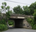
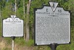
The Richmond, Fredericksburg and Potomac Railroad was extended to its terminus here at Aquia Landing in 1846.  By steamboat and railroad, travelers from Washington, D.C., to Richmond could complete in 9 hours a journey that took 38 hours by stagecoach.  In May-June 1861, Confederate batteries at Aquia landing exchanged fire with Union gunboats.  The first use of nautical mines (“torpedoes”) in the war occurred here on 7-July 1861 against the U.S.S. Pawnee.  After the Confederates abandoned the site in 1862, the Union army built new wharves and storage buildings for supplies.  The army burned them in 1863, when it pursued the Confederate army into Pennsylvania.  The railroad was extended across Aquia Creek in 1872.

Supply Base for the Union Army

Supply Base for the Union Army MarkerAquia Landing’s location on the Potomac River, coupled with its access to the R. F.&P. Railroad, made it an important supply base for the Union army.  Food, clothing and other equipment were shipped down the Potomac River, unloaded here, and sent to the front by train.  Recognizing its potential importance to the Union Army, Confederate troops destroyed Aquia Landing in April 1862 and tore up the railroad tracks running between here and Fredericksburg.  The Union Army immediately rebuilt these facilities but then foolishly destroyed them upon evacuating the area in September.

Gen. Ambrose Burnside rebuilt Aquia Landing again in November 1862 to supply his army during the Fredericksburg Campaign, adding an additional wharf at Youbedam Point, farther out on the Potomac River. The Confederates destroyed these structures in June 1863 after the Federals abandoned Aquia Landing and marched north to Gettysburg.

In May 1864 Gen. U.S. Grant used Belle Plains, six miles southeast, as his main supply base while rebuilding Aquia Landing.  As Grant pushed toward Richmond, he abandoned Aquia in favor of supply depots farther south.  The Confederates once again destroyed it after the Federals left.  This time is was not rebuilt.
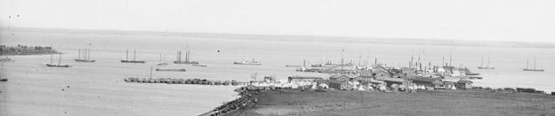
Aquia Creek Landing Embarkation of 9th Army Corps for Fort Monroe (Feb 1863)The Union Army used Aquia Landing for moving troops as well as supplies.  This photograph shows the Ninth Corps embarking at Aquia Creek in February 1863 en route to Newport News, Virginia.

When the water at Aquia Landing proved too shallow for deep-draft vessels, Ambrose Burnside constructed a new wharf at Youbedam Point, closer to the Potomac River.

As the Union Army moved south it used tidewater rivers for supply. Aquia Landing, Port Royal, White House and City Point became supply bases for Union bases for Union campaigns.

Steamships, Stages and Slave Trade

Aquia Landing Marker 
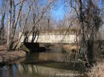
Aquia Landing (pronounced ‘un kwyy´yuh’), here at the junction of Aquia Creek and the Potomac River (to your right) was once a vital hub in Virginia’s transportation network. As early as 1815 steamboats from Washington and Alexandria made regular trips here, transferring passengers, mail, and even slaves to coaches bound for points south.

In 1842, the Richmond, Fredericksburg, and Potomac Railroad completed its line to Aquia, reducing travel time between Washington and Richmond. The junction here of steamboat and rail marked Aquia as an important place in antebellum Virginia and a major crossroads of the interstate slave trade.

By the 1850s.Virginia was exporting more slaves than any other state. Thousands of them, often handcuffed and packed amidst the cargo, passed through Aquia bound for slave markets farther south. From Aquia, most traveled onward by coach or, after 1842, by train. Some larger groups were forced to walk in chained gangs, or coffles, to destinations as far as 300 miles away.

Early Escape Route

Aquia Landing Historic MarkerThe opening of the rail line to Aquia in 1842 provided opportunity for slaves seeking freedom. In 1848, slaves William and Ellen Craft of Georgia embarked on their dangerous journey to escape. Ellen, born of a slave mother and white father disguised herself as white man seeking medical treatment in the north. William assumed the treatment in the North. William assumed the role of her body servant. They traveled by train, carriage, and steamship from Georgia to Philadelphia, passing unchallenged through Aquia Landing. They reached Philadelphia—and freedom—on Christmas day 1848.

Three months later, Henry “Box” Brown became one of the most famous fugitives in American history. A slave in Richmond, Brown packed himself in a wooden box to be mailed to freedom. By wagon, train, and steamboat, Brown traveled north, sometimes upside down. After 27 hours and undetected passage through Aquia Landing, the Express Mail box carrying Henry Box Brown was delivered in Philadelphia, its occupant a slave no more.

Gateway to Freedom

Aquia Landing Gateway to Freedom MarkerDuring the Civil War, most white Stafford residents greeted the arrival of the Union army in April 1862 with outrage and fear. But many slaves throughout the region rejoiced at the opportunity for freedom. Thousands left their houses, farms, and plantations, heading north toward the Union army.

Some “contrabands” (as the army called them), took jobs with the Union army, often as paid servants to officers. They earned between 25 and 40 cents per day, plus a ration. But for most former slaves, their journey to freedom continued to and culminated at Aquia Landing. Soldiers shepherded them onto steamboats for the short journey up the Potomac to Washington, D.C.

When the Union army evacuated the area in September 1862, a final burst of freedom-seekers flooded Aquia Landing. Among them was Fredericksburg slave John Washington, who slipped aboard the Washington-bound steamer Keyport (above). That spring and summer, as many as 10,000 slaves made the journey into Union lines—to freedom.

Related Links


Government Island

191 Coal Landing Road, Stafford County, Virginia

Government Island Now Open Billboard Sign
Government Island SignsPhoto of Government Island Quarry Historic MarkerWelcome to Government Island.  This 17-acre historic site is an American quarry originally named Brent’s Island or Wiggington’s Island.  As early as 1694, stone was quarried from this site for use as architectural trim in Colonial America.  The quarry’s fine-grained sandstone was called Aquia (ah qui´ ah) stone, due to its locations along the Aquia Creek, or freestone, for its ability to be freely carved without splitting.  The stone was a desirable building material for its composition as well as its beautiful white color.

In 1791, the federal government purchased Brent’s island for the purpose of constructing the President’s House (latte referred to as the White House) and the United States Capitol.  Extensive quantities of freestone were extracted from this site from 1791 through the 1820s.

In 1791, President George Washington (who was in Stafford County 10 miles south of this site at FerryPhoto of the Government Island Site Selection Marker, Stafford County, Virginia Farm) appointed three Commissioners to oversee construction of the new federal capital city (later named Washington, D. C.).  The Commissioners sent Major Pierre Charles L’Enfant to survey the lands along the Potomac River for adequate deposits of freestone.

L’Enfant selected Brent’s Island for its bountiful supply of good quality freestone, proximity to the capital city, and accessibility for water-transit.

On December 2, 1791, L’Enfant purchased the quarry for the federal government.  Thereafter, the site was known as The Public Quarry.  Today, the site is commonly know as Government Island.

The Commissioners also contracted with other nearby, private quarry owners to supply additional building material.  The use of the quarries, in addition to Government Island, helped to further establish quarrying as an important industry in Stafford County.

Photo of the Architectural Features Sign at Government Island, Stafford County Virginia Aquia stone was easy to carve, which made it a natural choice for intricate decorative details and trim elements around windows and doors.  From the late 1600s through the 1700s, Aquia sandstone was commonly used for gravestones, boundary markers, fireplace mantels, millstones and bridges.  This stone was used throughout Virginia and the mid-Atlantic colonies.  During the Federal period, intricate carving of Aquia Stone created striking features at the White House and U.S. Capitol.

Approximately two miles northwest of this site stands Aquia Episcopal  (1751-1757), which has freestone architectural components, including keystones, quoins, and pediments. Aquia sandstone was used in other prominent Virginia buildings, such as Kenmore in Fredericksburg (ca. 1772), Gunston Hall at Mason Neck (1755-1760), and Christ Church in Alexandria (1767-1773).

Government Island - Quarrying the StoneQuarrying stone during the late 18th and early 19th centuries was very labor intensive.  Stone quarried here was cur and shipped with the use of simple machines and animal power.  Various workers were needed to extract the stone. A master-mason, usually a European who was a master in all aspects of stone work, would oversee the entire quarrying operation.  Skilled workers include stone cutters and stone carvers who extracted and rough-cut the stone into desire sizes.  Blacksmiths were constantly needed to make and sharpen the cutting tools, wedges, chisels, trimming hammers, sledge hammers, picks, mattocks and axes.  Tool marks are still visible in the quarry faces today.

Many common laborers, or unskilled laborers, worked the site.  Slaves were hired out by their owners who collected the slaves’ wages.  Workers received housing and food, which included “…one pound good pork or one pound and a half of beef and one pound flour per day…” along with a half pint of whiskey (Commissioners Letter, April 10, 1792).

How the Stone Was Quarried:  First, all vegetation was removed from the top of the stone.  Once the stone was exposed, a vertical stone face was picked away, creating a working area.  Two vertical channels or side trenches were made 20-feet apart, rectangular section. Grooves were chiseled along the stone face where wedges were inserted to remove a block from the large stone mass.  Once a block of stone was cut, it was hoisted out with a derrick and pulley system, placed on a skid, and hauled by oxen to the wharf.

Government Island, Stafford VirginiaIn 1647, Giles Brent established the first English settlement in this area along Aquia Creek.  Nearly 50 years later, George Brent, Giles Brent’s nephew, became the island’s first documented owner.  George purchased “..a small tongue or neck or Island of Land with small point of marsh…” in 1694.  The property remained in the Brent family for almost 100 years, during which time it was used as a private quarry.

In 1791, the property was purchased by the federal government, which bought all but one acre.  That one-acre parcel had been sold previously in 1786 to Robert Steuart, a stone mason from Baltimore, Maryland.  Steuart delineated his parcel with four stone boundary markers, the largest of which sill remains and is clearly marked with his initials, “R.S.” It is located nearby this sigh.

Down the trail, there is a large pit, lined with cut stone, which measures approximately 50 feet by 150 feet.  Its purpose is currently unknown.  However, due to its proximity to the quarry, the pit was likely connected to the quarrying operations.

Related Links

Kirkland Monument

Sunken Road, Fredericksburg, Virginia

The Kirkland Monument was erected by the Sate of South Carolina and the Commonwealth of Virginia.  The sculptor was Felix De Welden and depicts Sergeant Richard Kirkland giving water to Union wounded during the Battle of Fredericksburg, December, 1862.

Sergeant Richard Rowland Kirkland  is buried at the Quaker Cemetery in Camden, South Carolina.
Continue reading